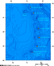
Hewison Point
Easternmost point of land on Thule IslandHewison Point is a point which forms the east side of Ferguson Bay and the southeast end of Thule Island, in the South Sandwich Islands. It was first charted by a Russian expedition under Fabian Gottlieb von Bellingshausen in 1819–20. It was recharted in 1930 by Discovery Investigations personnel on the Discovery II who named it for Lieutenant Colonel Hewison of Ferguson Brothers, Port Glasgow, Scotland, builders of the Discovery II.
Read article

Top Questions
AI generatedMore questions
Nearby Places
Operation Keyhole
1982 British military operation during the Falklands War

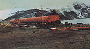
Corbeta Uruguay base
Former Argentine military outpost in the South Sandwich Islands (1976–1982)

Ferguson Bay
Beach Point
Headland in the South Sandwich Islands
Douglas Strait
Cape Flannery
Headland on Thule Island, South Snadwich Islands
Herd Point
Mount Larsen (South Sandwich Islands)
Mountain in the South Sandwich Islands